
Mapa topográfico Surigao City
Mapa interativo
Clique no mapa para exibir a altitude.
Sobre este mapa
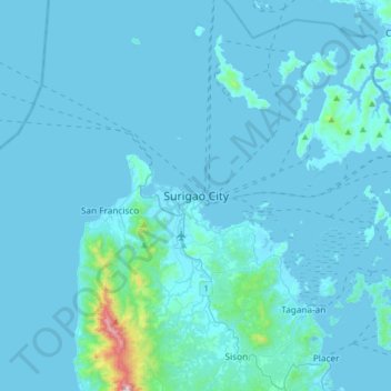
Nome: Mapa topográfico Surigao City, altitude, relevo.
Altitude média: 40 m
Altitude mínima: -1 m
Altitude máxima: 953 m
Surigao City is marked by rolling hills that gently buffers its eastern and western boundaries. To the south-west towers the Kabangkaan Ridge which divides the city from the municipality of San Francisco (formerly Anao-aon). Kinabutan River (otherwise known as Surigao River) meanders Surigao valley before it empties to the Surigao tidal basin, a shrinking mangrove swamp fast overtaken by the city's expansion. It has an average elevation of 19 meters or 65.5 ft. above sea level. The highest elevation on the mainland at the Kabangkaan Ridge has a peak elevation of 465 meters above sea level. Along the border of Tagana-an is Mapawa Peak with an elevation of 245 meters above sea level. Barangays Cabongbongan, Nabago and Capalayan are at the foot of its slopes.
Outros mapas topográficos
Clique em um mapa para visualizar sua topografia, sua altitude e seu relevo.
Sagasae Islet
Philippines > Surigao Del Norte > Surigao City
Sagasae Islet, Surigao City, Surigao Del Norte, Caraga, Philippines
Altitude média: 60 m