
Faça uma doação
Prepare-se para a sua próxima aventura:
Como Associado da Amazon, este site recebe uma comissão sobre compras elegíveis sem custo adicional para si.
Mapa topográfico Bayonne
Clique no mapa para exibir a altitude.
Faça uma doação
Prepare-se para a sua próxima aventura:
Como Associado da Amazon, este site recebe uma comissão sobre compras elegíveis sem custo adicional para si.
Bayonne
In the late Quaternary, the current topographic physiognomy was formed—i.e. a set of hills overlooking a swampy lowland. The promontory of Bassussarry–Marracq ultimately extended to the Labourdin foothills. The Grand Bayonne hill is an example. Similarly, on the right bank of the Nive, the heights of Château-Neuf (Mocoron Hill) met the latest advance of the plateau of Saint-Pierre-d'Irube (height 30 to 35 metres (98–115 feet)). On the right bank of the Adour, the heights of Castelnau (today the citadel), with an altitude of 35 to 40 metres (115–131 feet), and Fort (today Saint-Esprit), with an altitude of 20 to 25 metres (66–82 feet), rise above the Barthes of the Adour, the Nive, Bourgneuf, Saint-Frédéric, Sainte-Croix, Aritxague, and Pontots.
Faça uma doação
Prepare-se para a sua próxima aventura:
Como Associado da Amazon, este site recebe uma comissão sobre compras elegíveis sem custo adicional para si.
Sobre este mapa
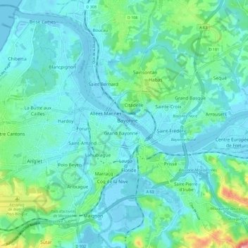
Nome: Mapa topográfico Bayonne, altitude, relevo.
Altitude média: 23 m
Altitude mínima: -4 m
Altitude máxima: 132 m
Faça uma doação
Prepare-se para a sua próxima aventura:
Como Associado da Amazon, este site recebe uma comissão sobre compras elegíveis sem custo adicional para si.