
Mapa topográfico Poughkeepsie
Mapa interativo
Clique no mapa para exibir a altitude.
Poughkeepsie
According to the United States Census Bureau, the city has an area of 5.7 square miles (14.8 km2), of which 5.1 square miles (13.3 km2) is land, and 0.23 square miles (0.6 km2) (10.05%) is water. Poughkeepsie lies approximately 75 miles (121 km) north of the center of the New York megacity. It is 73.5 miles (118.28 km) south of the New York state capital of Albany. The highest elevation of Poughkeepsie is 380 feet above sea level on College Hill. Its lowest is on the Hudson River.
Sobre este mapa
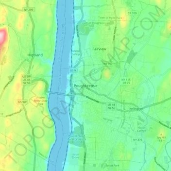
Nome: Mapa topográfico Poughkeepsie, altitude, relevo.
Altitude média: 65 m
Altitude mínima: -8 m
Altitude máxima: 241 m