
Mapa topográfico Château-Renault
Mapa interativo
Clique no mapa para exibir a altitude.
Sobre este mapa
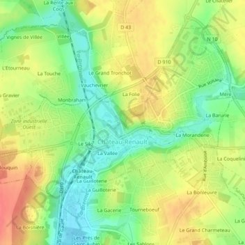
Nome: Mapa topográfico Château-Renault, altitude, relevo.
Altitude média: 112 m
Altitude mínima: 83 m
Altitude máxima: 141 m
Château-Renault is located on the Far-West of the Gâtine Tourangelle plateau, next to the Loir-et-Cher department and at the confluence of two rivers. The Gault and the Brenne. Its Elevation vary between 90 meters and 140 meters on the plateau. The area of the commune is 3.51 square kilometre.