
Mapa topográfico Vasant Kunj
Mapa interativo
Clique no mapa para exibir a altitude.
Sobre este mapa
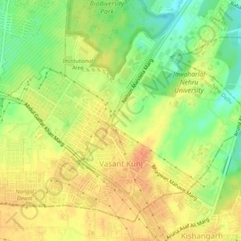
Nome: Mapa topográfico Vasant Kunj, altitude, relevo.
Local: Vasant Kunj, Vasant Vihar Tehsil, New Delhi, Delhi, India (28.52294 77.12763 28.54683 77.16452)
Altitude média: 261 m
Altitude mínima: 237 m
Altitude máxima: 278 m
Outros mapas topográficos
Clique em um mapa para visualizar sua topografia, sua altitude e seu relevo.
Ramakrishna Puram
Ramakrishna Puram, Vasant Vihar Tehsil, New Delhi, Delhi, India
Altitude média: 235 m
Central Ridge Reserve Forest
Central Ridge Reserve Forest, Delhi Cantonment, New Delhi, Delhi, India
Altitude média: 235 m
Chanakyapuri
Chanakyapuri, Chanakya Puri Tehsil, New Delhi, Delhi, 110021, India
Altitude média: 228 m
Vasant Vihar
Vasant Vihar, Delhi Cantonment, New Delhi, Delhi, 110057, India
Altitude média: 244 m
Lodhi Gardens
Lodhi Gardens, Rabindra Nagar, New Delhi, Chanakya Puri Tehsil, Delhi, India
Altitude média: 214 m