
Mapa topográfico Eisenerz
Mapa interativo
Clique no mapa para exibir a altitude.
Sobre este mapa
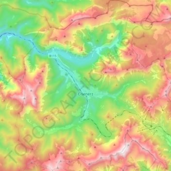
Nome: Mapa topográfico Eisenerz, altitude, relevo.
Local: Eisenerz, Bezirk Leoben, Styria, 8790, Austria (47.48237 14.80499 47.61450 14.98340)
Altitude média: 1283 m
Altitude mínima: 555 m
Altitude máxima: 2139 m
A few miles northwest of Eisenerz stands Leopoldstein Castle, and near it Leopoldstein Lake. This lake, with its dark green water at an elevation of 2,028 feet (618 m), and surrounded on all sides by high peaks, is not large and has a depth of 100 ft (30 m).
Outros mapas topográficos
Clique em um mapa para visualizar sua topografia, sua altitude e seu relevo.
Trofaiach
Austria > Styria > Bezirk Leoben
Trofaiach, Bezirk Leoben, Styria, 8793, Austria
Altitude média: 1066 m