
Mapa topográfico Jasper
Mapa interativo
Clique no mapa para exibir a altitude.
Sobre este mapa
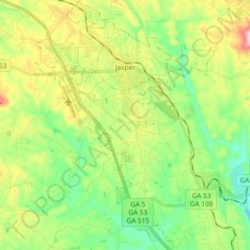
Nome: Mapa topográfico Jasper, altitude, relevo.
Local: Jasper, Pickens County, Georgia, 30142, United States (34.39175 -84.47465 34.49531 -84.38435)
Altitude média: 408 m
Altitude mínima: 278 m
Altitude máxima: 646 m
Jasper was founded in 1853 as seat of the newly formed Pickens County. It was incorporated in 1857 as a town and in 1957 as a city. The community is named for William Jasper, a hero of the American Revolutionary War. Jasper is situated at an elevation of 1,463 feet (446 m).
Outros mapas topográficos
Clique em um mapa para visualizar sua topografia, sua altitude e seu relevo.
Talking Rock
United States > Georgia > Pickens County
Talking Rock, Pickens County, Georgia, United States
Altitude média: 383 m