
Mapa topográfico Boston
Mapa interativo
Clique no mapa para exibir a altitude.
Sobre este mapa
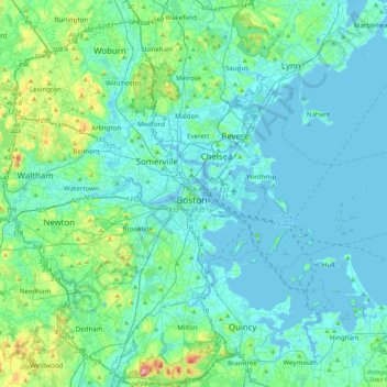
Nome: Mapa topográfico Boston, altitude, relevo.
Local: Boston, Suffolk County, Massachusetts, 02102, United States (42.20025 -71.21829 42.52025 -70.89829)
Altitude média: 26 m
Altitude mínima: -5 m
Altitude máxima: 189 m
Boston has an area of 89.63 sq mi (232.1 km2)—48.4 sq mi (125.4 km2) (54%) of land and41.2 sq mi (106.7 km2) (46%) of water. The city's official elevation, as measured at Logan International Airport, is 19 ft (5.8 m) above sea level. The highest point in Boston is Bellevue Hill at 330 ft (100 m) above sea level, and the lowest point is at sea level. Boston is situated on Boston Harbor, an arm of Massachusetts Bay, itself an arm of the Atlantic Ocean.
Outros mapas topográficos
Clique em um mapa para visualizar sua topografia, sua altitude e seu relevo.
Bellevue Hill
United States > Massachusetts > Suffolk County > Boston
Bellevue Hill, Boston, Suffolk County, Massachusetts, 02132, United States
Altitude média: 51 m
Bunker Hill Monument
United States > Massachusetts > Suffolk County > Boston
Bunker Hill Monument, Monument Square, Charlestown, Boston, Suffolk County, Massachusetts, 02129, United States
Altitude média: 6 m
West Roxbury
United States > Massachusetts > Suffolk County > Boston
West Roxbury, Boston, Suffolk County, Massachusetts, 02132, United States
Altitude média: 42 m
Franklin Park
United States > Massachusetts > Suffolk County > Boston
Franklin Park, Roxbury, Boston, Suffolk County, Massachusetts, United States
Altitude média: 30 m