
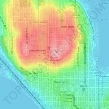
Mapa topográfico Queen Anne Hill
Mapa interativo
Clique no mapa para exibir a altitude.
Sobre este mapa
Nome: Mapa topográfico Queen Anne Hill, altitude, relevo.
Altitude média: 55 m
Altitude mínima: -8 m
Altitude máxima: 145 m
Outros mapas topográficos
Clique em um mapa para visualizar sua topografia, sua altitude e seu relevo.
Nantes Park
United States > Washington > King County > Seattle
Nantes Park, West Seattle, Seattle, King County, Washington, United States
Altitude média: 53 m
High Point
United States > Washington > King County > Seattle
High Point, Seattle, King County, Washington, 98126, United States
Altitude média: 88 m
Licton Springs
United States > Washington > King County > Seattle
Licton Springs, Ashworth Avenue North, Licton Springs, Greenwood, Seattle, King County, Washington, 98113, United States
Altitude média: 96 m
Lemur
United States > Washington > King County > Seattle
Lemur, Phinney Ridge, Seattle, King County, Washington, United States
Altitude média: 59 m
Arbor Heights
United States > Washington > King County > Seattle > Arbor Heights
Arbor Heights, Seattle, King County, Washington, 98146, United States
Altitude média: 60 m
Bitter Lake
United States > Washington > King County > Seattle > Bitter Lake
Bitter Lake, Seattle, King County, Washington, 98133, United States
Altitude média: 112 m