
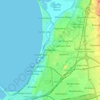
Mapa topográfico Milnerton
Mapa interativo
Clique no mapa para exibir a altitude.
Sobre este mapa
Nome: Mapa topográfico Milnerton, altitude, relevo.
Altitude média: 10 m
Altitude mínima: -2 m
Altitude máxima: 39 m
Outros mapas topográficos
Clique em um mapa para visualizar sua topografia, sua altitude e seu relevo.
Cape Town
South Africa > Western Cape > City of Cape Town
Cape Town, City of Cape Town, Western Cape, 8001, South Africa
Altitude média: 53 m
Cape Point
South Africa > Western Cape > City of Cape Town
Cape Point, Cape Town Ward 61, City of Cape Town, Western Cape, South Africa
Altitude média: 8 m
Beaulie Crescent Park
South Africa > Western Cape > City of Cape Town > Somerset West
Beaulie Crescent Park, Bellaire, Cape Town Ward 15, Somerset West, City of Cape Town, Western Cape, South Africa
Altitude média: 161 m
Strand
South Africa > Western Cape > City of Cape Town
Strand, City of Cape Town, Western Cape, 7136, South Africa
Altitude média: 22 m
Company Gardens Pond
South Africa > Western Cape > City of Cape Town > Cape Town
Company Gardens Pond, Cape Town Ward 115, Cape Town, City of Cape Town, Western Cape, 8001, South Africa
Altitude média: 82 m
Theal Road Park
South Africa > Western Cape > City of Cape Town > Milnerton
Theal Road Park, Tijgerhof, Milnerton, City of Cape Town, Western Cape, South Africa
Altitude média: 14 m
Verdi Close Park
South Africa > Western Cape > City of Cape Town
Verdi Close Park, Cape Town Ward 43, City of Cape Town, Western Cape, South Africa
Altitude média: 21 m
Simon's Town
South Africa > Western Cape > City of Cape Town
Simon's Town, City of Cape Town, Western Cape, 7995, South Africa
Altitude média: 134 m
False Bay
South Africa > Western Cape > City of Cape Town
False Bay, City of Cape Town, Western Cape, South Africa
Altitude média: 28 m
Pollock Park
South Africa > Western Cape > City of Cape Town
Pollock Park, Mountain View, Cape Town Ward 100, City of Cape Town, Western Cape, South Africa
Altitude média: 129 m
Khayelitsha
South Africa > Western Cape > City of Cape Town
Khayelitsha, City of Cape Town, Western Cape, 7784, South Africa
Altitude média: 26 m
Atlantis
South Africa > Western Cape > City of Cape Town
Atlantis, City of Cape Town, Western Cape, South Africa
Altitude média: 162 m
Table Mountain
South Africa > Western Cape > City of Cape Town > Cape Town
Table Mountain, Cape Town Ward 54, Cape Town, City of Cape Town, Western Cape, 8040, South Africa
Altitude média: 583 m
Masiphumelele
South Africa > Western Cape > City of Cape Town
Masiphumelele, City of Cape Town, Western Cape, 7979, South Africa
Altitude média: 56 m
Castle of Good Hope
South Africa > Western Cape > City of Cape Town > Cape Town
Castle of Good Hope, Nassau Bastion, Foreshore, Cape Town, City of Cape Town, Western Cape, 8001, South Africa
Altitude média: 38 m
Hout Bay
South Africa > Western Cape > City of Cape Town > Hout Bay
Hout Bay, City of Cape Town, Western Cape, South Africa
Altitude média: 193 m
Bokkemanskloof
South Africa > Western Cape > City of Cape Town > Hout Bay > Bokkemanskloof
Bokkemanskloof, Cape Town Ward 74, Hout Bay, City of Cape Town, Western Cape, 7806, South Africa
Altitude média: 261 m
Europe
South Africa > Western Cape > City of Cape Town
Europe, Cape Town Ward 40, City of Cape Town, Western Cape, 7490, South Africa
Altitude média: 36 m
Somerset West
South Africa > Western Cape > City of Cape Town
Somerset West, City of Cape Town, Western Cape, South Africa
Altitude média: 163 m
Noordhoek
South Africa > Western Cape > City of Cape Town > Noordhoek
Noordhoek, City of Cape Town, Western Cape, South Africa
Altitude média: 138 m
Fish Hoek
South Africa > Western Cape > City of Cape Town
Fish Hoek, City of Cape Town, Western Cape, South Africa
Altitude média: 80 m
North Peak
South Africa > Western Cape > City of Cape Town > Simon's Town
North Peak, Simon's Town, City of Cape Town, Western Cape, 7995, South Africa
Altitude média: 230 m
Mitchells Plain
South Africa > Western Cape > City of Cape Town
Mitchells Plain, City of Cape Town, Western Cape, 7785, South Africa
Altitude média: 24 m
Blue Downs
South Africa > Western Cape > City of Cape Town
Blue Downs, City of Cape Town, Western Cape, 7103, South Africa
Altitude média: 41 m
Bellville
South Africa > Western Cape > City of Cape Town
Bellville, City of Cape Town, Western Cape, South Africa
Altitude média: 115 m
Durbanville
South Africa > Western Cape > City of Cape Town
Durbanville, City of Cape Town, Western Cape, South Africa
Altitude média: 157 m