
Mapa topográfico Linglestown
Mapa interativo
Clique no mapa para exibir a altitude.
Sobre este mapa
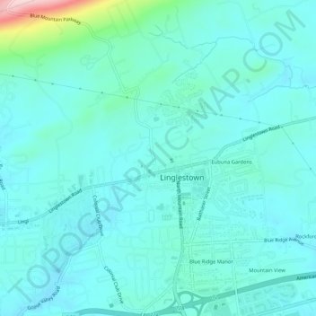
Nome: Mapa topográfico Linglestown, altitude, relevo.
Altitude média: 161 m
Altitude mínima: 124 m
Altitude máxima: 376 m
The highest elevation is 995 feet (303 m) on the south slope of Blue Mountain, along Blue Mountain Parkway north of the center of town. Pennsylvania Route 39 (Linglestown Road) passes east-to-west through the village, leading east 3.5 miles (5.6 km) to Exit 77 on Interstate 81 and west 5 miles (8 km) to Highway 22-322 at the north end of Harrisburg.