
Mapa topográfico Oslob
Mapa interativo
Clique no mapa para exibir a altitude.
Oslob
Generally, topography of the area is hilly and rolling, dominated by open grasslands and second growth forest. There are fairly level and rolling plateaus and valleys spread throughout the interior. These are some of the most suitable areas for upland agriculture. The highest mountain peak is 800 metres (2,600 ft) above sea level.
Sobre este mapa
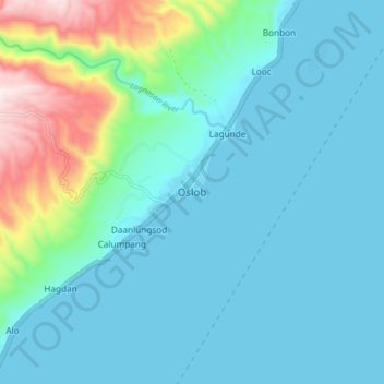
Nome: Mapa topográfico Oslob, altitude, relevo.
Local: Oslob, Cebu, Central Visayas, Philippines (9.48045 123.39352 9.56045 123.47352)
Altitude média: 118 m
Altitude mínima: 0 m
Altitude máxima: 700 m
Outros mapas topográficos
Clique em um mapa para visualizar sua topografia, sua altitude e seu relevo.