
Mapa topográfico Greyton Nature Reserve
Mapa interativo
Clique no mapa para exibir a altitude.
Sobre este mapa
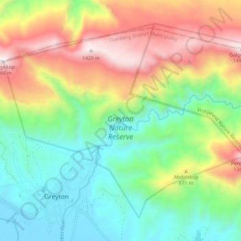
Nome: Mapa topográfico Greyton Nature Reserve, altitude, relevo.
Altitude média: 674 m
Altitude mínima: 200 m
Altitude máxima: 1443 m
Outros mapas topográficos
Clique em um mapa para visualizar sua topografia, sua altitude e seu relevo.
Bot River
RSA > Western Cape > Theewaterskloof Local Municipality
Bot River, Theewaterskloof Local Municipality, Overberg District Municipality, Western Cape, RSA
Altitude média: 85 m
Theewaterskloof Ward 12
RSA > Western Cape > Theewaterskloof Local Municipality
Theewaterskloof Ward 12, Theewaterskloof Local Municipality, Overberg District Municipality, Western Cape, RSA
Altitude média: 384 m
Klein River
RSA > Western Cape > Theewaterskloof Local Municipality
Klein River, Theewaterskloof Local Municipality, Overberg District Municipality, Western Cape, RSA
Altitude média: 191 m
Lebanon Nature Reserve
RSA > Western Cape > Theewaterskloof Local Municipality
Lebanon Nature Reserve, N2, Theewaterskloof Ward 7, Theewaterskloof Local Municipality, Overberg District Municipality, Western Cape, 7160, RSA
Altitude média: 307 m
Vrolijkheid Nature Reserve
RSA > Western Cape > Theewaterskloof Local Municipality
Vrolijkheid Nature Reserve, Theewaterskloof Ward 1, Theewaterskloof Local Municipality, Overberg District Municipality, Western Cape, RSA
Altitude média: 406 m