
Mapa topográfico Ingham Mills
Mapa interativo
Clique no mapa para exibir a altitude.
Sobre este mapa
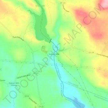
Nome: Mapa topográfico Ingham Mills, altitude, relevo.
Altitude média: 215 m
Altitude mínima: 147 m
Altitude máxima: 312 m
Outros mapas topográficos
Clique em um mapa para visualizar sua topografia, sua altitude e seu relevo.
East Creek
United States > New York > Herkimer County > Town of Manheim
East Creek, Town of Manheim, Herkimer County, New York, United States
Altitude média: 139 m
Ingham Mills Station
United States > New York > Herkimer County > Town of Manheim
Ingham Mills Station, Town of Manheim, Herkimer County, New York, United States
Altitude média: 189 m
Manheim Center
United States > New York > Herkimer County > Town of Manheim
Manheim Center, Town of Manheim, Herkimer County, New York, United States
Altitude média: 196 m