
Mapa topográfico Davos
Mapa interativo
Clique no mapa para exibir a altitude.
Sobre este mapa
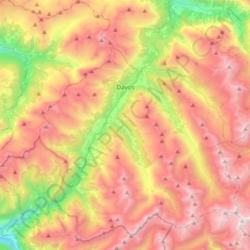
Nome: Mapa topográfico Davos, altitude, relevo.
Local: Davos, Prättigau/Davos, Grisons, Switzerland (46.67026 9.66912 46.85966 9.96706)
Altitude média: 2142 m
Altitude mínima: 994 m
Altitude máxima: 3177 m
The main village of Davos lies at the top of the narrow valley of the Landwasser at an altitude of 1,560 metres (5,120 ft), just below the Wolfgang Pass. Lake Davos is northeast of the village, formerly the source of the Landwasser.
Outros mapas topográficos
Clique em um mapa para visualizar sua topografia, sua altitude e seu relevo.
Davosersee
Switzerland > Grisons > Prättigau/Davos > Davos
Davosersee, Davos Dorf, Davos, Prättigau/Davos, Grisons, Switzerland
Altitude média: 1722 m
Landwasser
Switzerland > Grisons > Prättigau/Davos > Davos
Landwasser, Davos, Prättigau/Davos, Grisons, 7277, Switzerland
Altitude média: 2063 m
Davos
Switzerland > Grisons > Prättigau/Davos > Davos > Davos
Davos, Prättigau/Davos, Grisons, 7270, Switzerland
Altitude média: 2007 m
Klosters
Switzerland > Grisons > Prättigau/Davos
Klosters, Prättigau/Davos, Grisons, Switzerland
Altitude média: 2217 m