
Mapa topográfico Dodge City
Mapa interativo
Clique no mapa para exibir a altitude.
Sobre este mapa
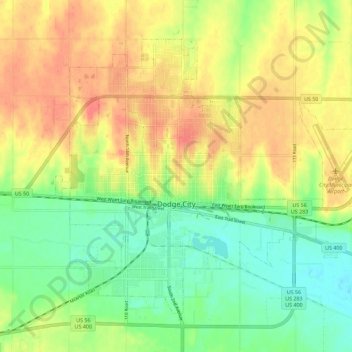
Nome: Mapa topográfico Dodge City, altitude, relevo.
Local: Dodge City, Ford County, Kansas, 67801, United States (37.72492 -100.05593 37.79469 -99.94277)
Altitude média: 777 m
Altitude mínima: 747 m
Altitude máxima: 809 m
Dodge City is located at 37°45′35″N 100°1′6″W / 37.75972°N 100.01833°W / 37.75972; -100.01833 (37.759671, −100.018212) at an elevation of 2,493 ft (760 m). It lies on the Arkansas River in the High Plains region of the Great Plains. The city sits above one of the world's largest underground water systems, the Ogallala Aquifer, and is 25 miles (40 km) from the eastern edge of the Hugoton Natural Gas Area. Located at the intersection of U. S. Routes 50, 56 and 283 in southwestern Kansas, Dodge City is 151 mi (243 km) west of Wichita, 199 mi (320 km) northeast of Amarillo, and 301 mi (484 km) southeast of Denver.
Outros mapas topográficos
Clique em um mapa para visualizar sua topografia, sua altitude e seu relevo.
Fort Dodge
United States > Kansas > Ford County
Fort Dodge, Ford County, Kansas, 67843, United States
Altitude média: 761 m
Bellefont
United States > Kansas > Ford County
Bellefont, Ford County, Kansas, United States
Altitude média: 720 m