
Faça uma doação
Prepare-se para a sua próxima aventura:
Como Associado da Amazon, este site recebe uma comissão sobre compras elegíveis sem custo adicional para si.
Mapa topográfico Bengough
Clique no mapa para exibir a altitude.
Faça uma doação
Prepare-se para a sua próxima aventura:
Como Associado da Amazon, este site recebe uma comissão sobre compras elegíveis sem custo adicional para si.
Bengough
Bengough is located within the Missouri Coteau near Willow Bunch Lake, Big Muddy Lake, Salt Lake and Channel Lake. Few well-defined streams or creeks are located near the townsite. The landscape where the town is located is characterized by pitted and rolling topography of the moraine deposits that dominate the landscape. Just south of Bengough is the Big Muddy Badlands.
Faça uma doação
Prepare-se para a sua próxima aventura:
Como Associado da Amazon, este site recebe uma comissão sobre compras elegíveis sem custo adicional para si.
Sobre este mapa
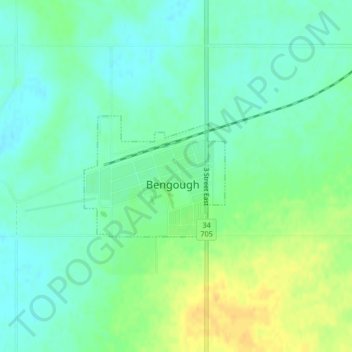
Nome: Mapa topográfico Bengough, altitude, relevo.
Local: Bengough, Division No. 2, Saskatchewan, S0C 0K0, Canada (49.39171 -105.13666 49.40099 -105.12006)
Altitude média: 690 m
Altitude mínima: 679 m
Altitude máxima: 708 m
Faça uma doação
Prepare-se para a sua próxima aventura:
Como Associado da Amazon, este site recebe uma comissão sobre compras elegíveis sem custo adicional para si.