
Mapa topográfico Hawksbill
Mapa interativo
Clique no mapa para exibir a altitude.
Sobre este mapa
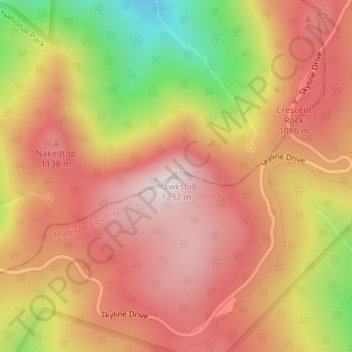
Nome: Mapa topográfico Hawksbill, altitude, relevo.
Local: Hawksbill, Madison County, Virginia, United States (38.55531 -78.39519 38.55541 -78.39509)
Altitude média: 993 m
Altitude mínima: 623 m
Altitude máxima: 1217 m
Hawksbill Mountain is a mountain with an elevation of 4,050 feet (1,234 m). Marking the border between Madison County and Page County in Virginia, the summit of Hawksbill Mountain is the highest point in Shenandoah National Park, as well as the highest point in both Madison and Page counties.
Outros mapas topográficos
Clique em um mapa para visualizar sua topografia, sua altitude e seu relevo.
Big Meadows
United States > Virginia > Madison County
Big Meadows, Madison County, Virginia, United States
Altitude média: 868 m