
Mapa topográfico Summit County
Mapa interativo
Clique no mapa para exibir a altitude.
Sobre este mapa
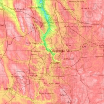
Nome: Mapa topográfico Summit County, altitude, relevo.
Local: Summit County, Ohio, United States of America (40.90650 -81.68849 41.35113 -81.39169)
Altitude média: 327 m
Altitude mínima: 187 m
Altitude máxima: 405 m
Summit County is an urban county in the U.S. state of Ohio. As of the 2010 census, the population was 541,781 making it the fourth-most populous county in Ohio. Its county seat is Akron. The county was formed on March 3, 1840, from portions of Medina, Portage and Stark Counties. It was named "Summit County" because the highest elevation on the Ohio and Erie Canal is located in the county.
Outros mapas topográficos
Clique em um mapa para visualizar sua topografia, sua altitude e seu relevo.
Erie County
United States of America > Ohio
Erie County, Ohio, United States of America
Altitude média: 185 m
Cuyahoga County
United States of America > Ohio
Cuyahoga County, Ohio, United States of America
Altitude média: 211 m