
Mapa topográfico Riddle
Mapa interativo
Clique no mapa para exibir a altitude.
Riddle
Riddle is about 25 miles (40 km) south of Roseburg and 220 miles (350 km) south of Portland. It lies about 4 miles (6.4 km) west of Oregon Route 99 (Interstate 5) at an elevation of about 700 feet (210 m) above sea level. Cow Creek flows by Riddle before entering the nearby South Umpqua River.
Sobre este mapa
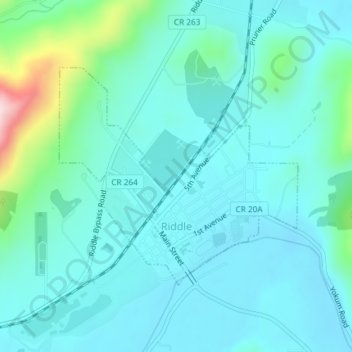
Nome: Mapa topográfico Riddle, altitude, relevo.
Local: Riddle, Douglas County, Oregon, United States of America (42.94641 -123.37653 42.96311 -123.35149)
Altitude média: 246 m
Altitude mínima: 195 m
Altitude máxima: 504 m