
Mapa topográfico Warwick
Mapa interativo
Clique no mapa para exibir a altitude.
Sobre este mapa
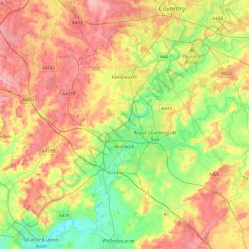
Nome: Mapa topográfico Warwick, altitude, relevo.
Local: Warwick, Warwickshire, West Midlands, England, United Kingdom (52.21370 -1.78018 52.38928 -1.40608)
Altitude média: 87 m
Altitude mínima: 35 m
Altitude máxima: 145 m
Warwick experiences the usual English maritime climate, marked by a narrow temperature range, mild winters and cool summers. The nearest official Met Office weather station is at Wellesbourne, about 6 miles (10 km) south of the town centre and at a similar elevation.
Outros mapas topográficos
Clique em um mapa para visualizar sua topografia, sua altitude e seu relevo.
Warwick Castle
United Kingdom > England > Warwickshire > Warwick
Warwick Castle, Northern Tower, Cliff Hill, Warwick, Warwickshire, England, CV34 4QX, United Kingdom
Altitude média: 56 m
Sherbourne
United Kingdom > England > Warwickshire > Warwick
Sherbourne, Warwick, Warwickshire, England, United Kingdom
Altitude média: 56 m
Leek Wootton
United Kingdom > England > Warwickshire > Warwick
Leek Wootton, Warwick, Warwickshire, England, CV35 7RS, United Kingdom
Altitude média: 76 m