
Mapa topográfico Louvrange
Mapa interativo
Clique no mapa para exibir a altitude.
Sobre este mapa
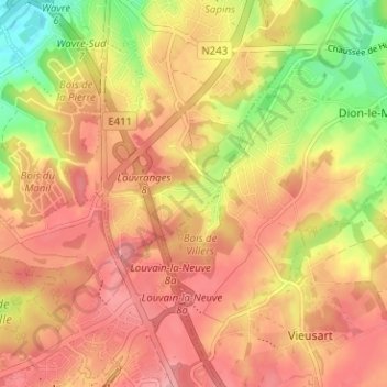
Nome: Mapa topográfico Louvrange, altitude, relevo.
Altitude média: 107 m
Altitude mínima: 42 m
Altitude máxima: 145 m
Outros mapas topográficos
Clique em um mapa para visualizar sua topografia, sua altitude e seu relevo.
Basse-Wavre
Belgique > Brabant wallon > Nivelles > Wavre
Basse-Wavre, Wavre, Nivelles, Brabant wallon, Wallonie, 1300, Belgique
Altitude média: 74 m
Limal
Belgique > Brabant wallon > Nivelles > Wavre
Limal, Wavre, Nivelles, Brabant wallon, Wallonie, 1302, Belgique
Altitude média: 86 m
Le Culot
Belgique > Brabant wallon > Nivelles > Wavre
Le Culot, Wavre, Nivelles, Brabant wallon, Wallonie, 1300, Belgique
Altitude média: 71 m