
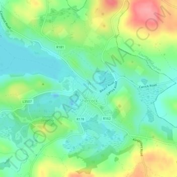
Mapa topográfico Shercock
Mapa interativo
Clique no mapa para exibir a altitude.
Sobre este mapa
Nome: Mapa topográfico Shercock, altitude, relevo.
Altitude média: 117 m
Altitude mínima: 85 m
Altitude máxima: 176 m
The region is known as "Drumlin Country" owing to its topography of small hills and lakes formed at the end of the last ice age. County Cavan borders County Fermanagh and County Monaghan. Together, they form the colloquially named "Drumlin County". Shercock lies on the border between County Cavan and County Monaghan.
Outros mapas topográficos
Clique em um mapa para visualizar sua topografia, sua altitude e seu relevo.
Kilnaleck
Kilnaleck, Ballyjamesduff Municipal District, County Cavan, A82 X567, Ireland
Altitude média: 114 m
Callanagh Lower
Callanagh Lower, Drumlumman ED, Ballyjamesduff Municipal District, County Cavan, Ulster, Ireland
Altitude média: 85 m
Virginia
Virginia, Virginia ED, Ballyjamesduff Municipal District, County Cavan, Ireland
Altitude média: 98 m
Crossdoney
Crossdoney, Ballyjamesduff Municipal District, County Cavan, H12 K727, Ireland
Altitude média: 67 m
Bailieborough
Bailieborough, Bailieborough ED, Bailieborough-Cootehill Municipal District, County Cavan, A82 NX86, Ireland
Altitude média: 162 m
Mount Nugent
Mount Nugent, Ballyjamesduff Municipal District, County Cavan, Ulster, Ireland
Altitude média: 74 m
Ballyjamesduff
Ballyjamesduff, Ballyjamesduff Municipal District, County Cavan, Ulster, A82 CT95, Ireland
Altitude média: 118 m
Ballyconnell
Ballyconnell, Ballyconnell ED, Cavan-Belturbet Municipal District, County Cavan, Ulster, H14 EC99, Ireland
Altitude média: 68 m
Cootehill
Cootehill, Bailieborough-Cootehill Municipal District, County Cavan, Ulster, Ireland
Altitude média: 89 m
Cornafean
Cornafean, Ballyjamesduff Municipal District, County Cavan, Ulster, Ireland
Altitude média: 82 m
Killashandra
Killashandra, Killashandra ED, Cavan-Belturbet Municipal District, County Cavan, Ulster, Ireland
Altitude média: 62 m
Loch Gowna (Scrabby)
Loch Gowna (Scrabby), Scrabby ED, Ballyjamesduff Municipal District, County Cavan, Ulster, Ireland
Altitude média: 80 m
Snugborough
Snugborough, Ballyconnell ED, Cavan-Belturbet Municipal District, County Cavan, Ulster, Ireland
Altitude média: 174 m
Tullycoe
Tullycoe, Larah North ED, Bailieborough-Cootehill Municipal District, County Cavan, Ulster, Ireland
Altitude média: 96 m
Togher or Danesfort Demesne
Togher or Danesfort Demesne, Killykeen ED, Cavan-Belturbet Municipal District, County Cavan, Ulster, Ireland
Altitude média: 64 m
Corfad
Corfad, Stradone ED, Bailieborough-Cootehill Municipal District, County Cavan, Ireland
Altitude média: 130 m
Lisdaran
Lisdaran, Cavan Rural ED, Cavan-Belturbet Municipal District, County Cavan, Ulster, Ireland
Altitude média: 73 m
Cormeen
Cormeen, Larah South ED, Bailieborough-Cootehill Municipal District, County Cavan, Ulster, Ireland
Altitude média: 133 m
Monaghanoose
Monaghanoose, Drumanespick ED, Bailieborough-Cootehill Municipal District, County Cavan, Ireland
Altitude média: 140 m
Bailieborough
Bailieborough, Bailieborough-Cootehill Municipal District, County Cavan, Ulster, A82 NX86, Ireland
Altitude média: 163 m
Cleffin
Cleffin, Killinkere ED, Bailieborough-Cootehill Municipal District, County Cavan, Ulster, Ireland
Altitude média: 128 m
Bailieborough
Ireland > County Cavan > Bailieborough
Bailieborough, Bailieborough-Cootehill Municipal District, County Cavan, A82 NX86, Ireland
Altitude média: 169 m
Seefin
Seefin, Drumanespick ED, Bailieborough-Cootehill Municipal District, County Cavan, Ireland
Altitude média: 194 m
Kilnavert
Kilnavert, Ballymagauran ED, Cavan-Belturbet Municipal District, County Cavan, Ireland
Altitude média: 68 m
Killaghaduff
Killaghaduff, Swanlinbar ED, Cavan-Belturbet Municipal District, County Cavan, Ireland
Altitude média: 91 m
Drumgart
Drumgart, Ardue ED, Cavan-Belturbet Municipal District, County Cavan, Ireland
Altitude média: 55 m
Cornamucklagh
Ireland > County Cavan > Cornamucklagh
Cornamucklagh, Crossdoney ED, Ballyjamesduff Municipal District, County Cavan, H12K727, Ireland
Altitude média: 61 m
Bailieborough-Cootehill Municipal District
Bailieborough-Cootehill Municipal District, County Cavan, Ulster, Ireland
Altitude média: 122 m
Carrickallen
Carrickallen, Larah North ED, Bailieborough-Cootehill Municipal District, County Cavan, Ireland
Altitude média: 185 m
Dunaree
Dunaree, Kingscourt ED, Bailieborough-Cootehill Municipal District, County Cavan, Ireland
Altitude média: 115 m
Laraweehan
Laraweehan, Knappagh ED, Bailieborough-Cootehill Municipal District, County Cavan, Ireland
Altitude média: 104 m
Drumlane
Drumlane, Drung ED, Bailieborough-Cootehill Municipal District, County Cavan, Ireland
Altitude média: 93 m
Cavan-Belturbet Municipal District
Cavan-Belturbet Municipal District, County Cavan, Ulster, Ireland
Altitude média: 111 m
Glangevlin
Glangevlin, Cavan-Belturbet Municipal District, County Cavan, Ulster, Ireland
Altitude média: 185 m
Kilcogy
Kilcogy, Ballyjamesduff Municipal District, County Cavan, Ulster, Ireland
Altitude média: 89 m