
Mapa topográfico Bayview
Mapa interativo
Clique no mapa para exibir a altitude.
Sobre este mapa
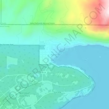
Nome: Mapa topográfico Bayview, altitude, relevo.
Local: Bayview, Kootenai County, Idaho, United States (47.96033 -116.58043 48.00033 -116.54043)
Altitude média: 733 m
Altitude mínima: 616 m
Altitude máxima: 1195 m
Bayview is an unincorporated community in the northwest United States, located in Kootenai County, Idaho, north of Coeur d'Alene. On the southwest shore of Lake Pend Oreille, Bayview is seven miles (11 km) east-northeast of Athol. The community is served by State Highway 54 and a post office with ZIP code 83803; its approximate elevation is 2,100 feet (640 m) above sea level. Nearby is Farragut State Park, formerly the Farragut Naval Training Station, a major training facility during World War II.
Outros mapas topográficos
Clique em um mapa para visualizar sua topografia, sua altitude e seu relevo.
Coeur d'Alene
United States > Idaho > Kootenai County
Coeur d'Alene, Kootenai County, Idaho, United States
Altitude média: 719 m
Athol
United States > Idaho > Kootenai County
Athol, Kootenai County, Idaho, United States
Altitude média: 733 m
Post Falls
United States > Idaho > Kootenai County
Post Falls, Kootenai County, Idaho, 83854, United States
Altitude média: 710 m
Hayden
United States > Idaho > Kootenai County
Hayden, Kootenai County, Idaho, 83835, United States
Altitude média: 717 m
Rathdrum
United States > Idaho > Kootenai County
Rathdrum, Kootenai County, Idaho, 83858, United States
Altitude média: 701 m