
Faça uma doação
Prepare-se para a sua próxima aventura:
Como Associado da Amazon, este site recebe uma comissão sobre compras elegíveis sem custo adicional para si.
Mapa topográfico Prince George
Clique no mapa para exibir a altitude.
Faça uma doação
Prepare-se para a sua próxima aventura:
Como Associado da Amazon, este site recebe uma comissão sobre compras elegíveis sem custo adicional para si.
Prince George
The area has a humid continental climate (Köppen climate classification Dfb, Trewartha Dclo), but is close to (and once had) a subarctic climate (Dfc) as May and September averages are both close to the 10 °C (50 °F) threshold. Winters are milder than the latitude and elevation might suggest: the January average is −9.6 °C (14.7 °F), and there are an average of 38 days from December to February where the high reaches or surpasses freezing. Winter months in which Pacific air masses dominate may thaw on a majority of days, as in January 2006 when the mean daily maximum temperature was 1.5 °C (34.7 °F). On the other hand, Arctic air masses can settle over the city for weeks at a time; in rare cases, such as January 1950, the temperature stays well below freezing over a whole calendar month. Summer days are warm, with a July high of 23.1 °C (73.6 °F), but lows are often cool, with monthly lows averaging below 10 °C (50 °F). The transition between winter and summer, however, is short. There is some precipitation year-round, but February to April is the driest period. At the airport snow averages 205.1 cm (80.7 in) each year and is heaviest in December and January, usually, but not always, falling between October and May.
Faça uma doação
Prepare-se para a sua próxima aventura:
Como Associado da Amazon, este site recebe uma comissão sobre compras elegíveis sem custo adicional para si.
Sobre este mapa
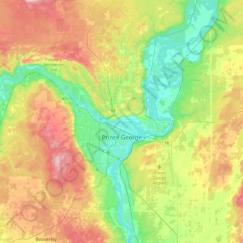
Nome: Mapa topográfico Prince George, altitude, relevo.
Altitude média: 685 m
Altitude mínima: 555 m
Altitude máxima: 886 m
Faça uma doação
Prepare-se para a sua próxima aventura:
Como Associado da Amazon, este site recebe uma comissão sobre compras elegíveis sem custo adicional para si.
Outros mapas topográficos
Clique em um mapa para visualizar sua topografia, sua altitude e seu relevo.
Mount Robson
Canada > British Columbia > Regional District of Fraser-Fort George > Area H (Robson Valley/Canoe)
The north face can be seen from Berg Lake, and reached by a 19 km (11.8 mi) hike. The lake is approximately 2 km long and lies at 1,646 m (5,400 ft) elevation. There are backcountry campgrounds at each end of the lake and a log shelter on its banks, named Hargreaves Shelter in honor of the Hargreaves family…
Altitude média: 3042 m
Crooked River
Canada > British Columbia > Regional District of Fraser-Fort George > Area G (Crooked River/Parsnip)
Altitude média: 749 m
Carp Lake
Canada > British Columbia > Regional District of Fraser-Fort George > Area G (Crooked River/Parsnip)
Altitude média: 865 m
Mount Tabor
Canada > British Columbia > Regional District of Fraser-Fort George > Area D (Tabor Lake/Stone Creek)
Altitude média: 1119 m
Faça uma doação
Prepare-se para a sua próxima aventura:
Como Associado da Amazon, este site recebe uma comissão sobre compras elegíveis sem custo adicional para si.
Narrow Lake
Canada > British Columbia > Regional District of Fraser-Fort George > Area F (Willow River/Upper Fraser)
Altitude média: 1251 m
Punchaw Lake
Canada > British Columbia > Regional District of Fraser-Fort George > Area C (Chilako River/Nechako)
Altitude média: 788 m
Red Rock
Canada > British Columbia > Regional District of Fraser-Fort George > Area D (Tabor Lake/Stone Creek)
Altitude média: 651 m
Prince George
Canada > British Columbia > Regional District of Fraser-Fort George > Prince George
Altitude média: 708 m
Faça uma doação
Prepare-se para a sua próxima aventura:
Como Associado da Amazon, este site recebe uma comissão sobre compras elegíveis sem custo adicional para si.
Willow River
Canada > British Columbia > Regional District of Fraser-Fort George > Area F (Willow River/Upper Fraser)
Altitude média: 621 m
Hixon
Canada > British Columbia > Regional District of Fraser-Fort George > Area E (Woodpecker/Hixon)
Altitude média: 683 m
Tête Jaune Cache
Canada > British Columbia > Regional District of Fraser-Fort George > Area H (Robson Valley/Canoe)
Altitude média: 789 m
Aleza Lake
Canada > British Columbia > Regional District of Fraser-Fort George > Area F (Willow River/Upper Fraser)
Altitude média: 646 m
Faça uma doação
Prepare-se para a sua próxima aventura:
Como Associado da Amazon, este site recebe uma comissão sobre compras elegíveis sem custo adicional para si.
Fraserview
Canada > British Columbia > Regional District of Fraser-Fort George > Prince George
Altitude média: 590 m
Mount St. Patrick
Canada > British Columbia > Regional District of Fraser-Fort George > Area F (Willow River/Upper Fraser)
Altitude média: 2290 m
Salmon Lake
Canada > British Columbia > Regional District of Fraser-Fort George > Area G (Crooked River/Parsnip)
Altitude média: 909 m
Hansard Lake
Canada > British Columbia > Regional District of Fraser-Fort George > Area F (Willow River/Upper Fraser)
Altitude média: 639 m
Faça uma doação
Prepare-se para a sua próxima aventura:
Como Associado da Amazon, este site recebe uma comissão sobre compras elegíveis sem custo adicional para si.
Rocky Mountains
Canada > British Columbia > Regional District of Fraser-Fort George > Area F (Willow River/Upper Fraser)
Altitude média: 1252 m
Whitehorn Mountain
Canada > British Columbia > Regional District of Fraser-Fort George > Area H (Robson Valley/Canoe)
Altitude média: 2553 m
Raven Lake
Canada > British Columbia > Regional District of Fraser-Fort George > Area F (Willow River/Upper Fraser)
Altitude média: 1630 m
Mount Sir Wilfrid Laurier
Canada > British Columbia > Regional District of Fraser-Fort George > Area H (Robson Valley/Canoe)
Altitude média: 2900 m
Faça uma doação
Prepare-se para a sua próxima aventura:
Como Associado da Amazon, este site recebe uma comissão sobre compras elegíveis sem custo adicional para si.
Cariboo Mountains
Canada > British Columbia > Regional District of Fraser-Fort George > Area H (Robson Valley/Canoe)
Altitude média: 2447 m
Bear Lake
Canada > British Columbia > Regional District of Fraser-Fort George > Area G (Crooked River/Parsnip)
Altitude média: 726 m
Eddy
Canada > British Columbia > Regional District of Fraser-Fort George > Area H (Robson Valley/Canoe)
Altitude média: 729 m
Goat River
Canada > British Columbia > Regional District of Fraser-Fort George > Area H (Robson Valley/Canoe)
Altitude média: 705 m
Faça uma doação
Prepare-se para a sua próxima aventura:
Como Associado da Amazon, este site recebe uma comissão sobre compras elegíveis sem custo adicional para si.
Mugaha Marsh
Canada > British Columbia > Regional District of Fraser-Fort George > Area G (Crooked River/Parsnip)
Altitude média: 681 m
Cottonwood Island Park
Canada > British Columbia > Regional District of Fraser-Fort George > Prince George
Altitude média: 586 m
Mount Robson
Canada > British Columbia > Regional District of Fraser-Fort George > Area H (Robson Valley/Canoe)
The north face can be seen from Berg Lake, and reached by a 19 km (12 mi) hike. The lake is approximately 2 km long and lies at 1,646 m (5,400 ft) elevation. There are backcountry campgrounds at each end of the lake and a log shelter on its banks, named Hargreaves Shelter in honor of the Hargreaves family who…
Altitude média: 3037 m
Brûlé Lake
Canada > British Columbia > Regional District of Fraser-Fort George > Area A (Salmon River/Lakes)
Altitude média: 780 m
Faça uma doação
Prepare-se para a sua próxima aventura:
Como Associado da Amazon, este site recebe uma comissão sobre compras elegíveis sem custo adicional para si.
Mount Robson
Canada > British Columbia > Regional District of Fraser-Fort George > Area H (Robson Valley/Canoe)
The north face can be seen from Berg Lake, and reached by a 19 km (12 mi) hike. The lake is approximately 2 km long and lies at 1,646 m (5,400 ft) elevation. There are backcountry campgrounds at each end of the lake and a log shelter on its banks, named Hargreaves Shelter in honor of the Hargreaves family who…
Altitude média: 3042 m
Rocky Mountains
Canada > British Columbia > Regional District of Fraser-Fort George > Area F (Willow River/Upper Fraser)
Altitude média: 1421 m
Mount Robson
Canada > British Columbia > Regional District of Fraser-Fort George > Area H (Robson Valley/Canoe)
The north face can be seen from Berg Lake, and reached by a 19 km (12 mi) hike. The lake is approximately 2 km long and lies at 1,646 m (5,400 ft) elevation. There are backcountry campgrounds at each end of the lake and a log shelter on its banks, named Hargreaves Shelter in honor of the Hargreaves family who…
Altitude média: 3042 m
Faça uma doação
Prepare-se para a sua próxima aventura:
Como Associado da Amazon, este site recebe uma comissão sobre compras elegíveis sem custo adicional para si.
McLeod Lake
Canada > British Columbia > Regional District of Fraser-Fort George > Area G (Crooked River/Parsnip)
A point in the marshes on its southern shore of nearby Summit Lake marks the low point of the divide between the drainages of the Fraser and Peace Rivers, As such it is significant as the prominence col between all points south in the Rockies and beyond and their "parent" summits in northern BC and Alaska.…
Altitude média: 701 m
Coyote Lake
Canada > British Columbia > Regional District of Fraser-Fort George > Area G (Crooked River/Parsnip)
Altitude média: 849 m
Whitehorn Mountain
Canada > British Columbia > Regional District of Fraser-Fort George > Area H (Robson Valley/Canoe)
Altitude média: 2553 m