
Faça uma doação
Prepare-se para a sua próxima aventura:
Como Associado da Amazon, este site recebe uma comissão sobre compras elegíveis sem custo adicional para si.
Mapa topográfico Mill Valley
Clique no mapa para exibir a altitude.
Faça uma doação
Prepare-se para a sua próxima aventura:
Como Associado da Amazon, este site recebe uma comissão sobre compras elegíveis sem custo adicional para si.
Sobre este mapa
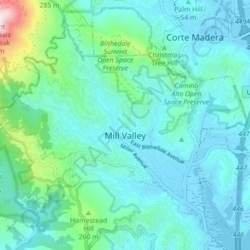
Nome: Mapa topográfico Mill Valley, altitude, relevo.
Local: Mill Valley, Marin County, California, United States (37.88648 -122.57698 37.92963 -122.51438)
Altitude média: 112 m
Altitude mínima: -3 m
Altitude máxima: 707 m
Faça uma doação
Prepare-se para a sua próxima aventura:
Como Associado da Amazon, este site recebe uma comissão sobre compras elegíveis sem custo adicional para si.
Outros mapas topográficos
Clique em um mapa para visualizar sua topografia, sua altitude e seu relevo.
Woodacre
United States > California > Marin County
The community is located at 38°00′46″N 122°38′43″W / 38.01278°N 122.64528°W / 38.01278; -122.64528 in the eastern half of the San Geronimo Valley of central Marin County. San Geronimo and Lagunitas-Forest Knolls are to its west. Woodacre is located 8 miles (13 km) south-southwest of…
Altitude média: 246 m
Faça uma doação
Prepare-se para a sua próxima aventura:
Como Associado da Amazon, este site recebe uma comissão sobre compras elegíveis sem custo adicional para si.
Bolinas
United States > California > Marin County
Bolinas sits at an elevation of 36 feet (11 m) above sea level. It is bound on the northeast by Bolinas Lagoon and Kent Island, on the south by Bolinas Bay and Duxbury Point, on the southwest by the Pacific Ocean, and on the northwest by Point Reyes National Seashore. According to the United States Census…
Altitude média: 28 m
Faça uma doação
Prepare-se para a sua próxima aventura:
Como Associado da Amazon, este site recebe uma comissão sobre compras elegíveis sem custo adicional para si.
Faça uma doação
Prepare-se para a sua próxima aventura:
Como Associado da Amazon, este site recebe uma comissão sobre compras elegíveis sem custo adicional para si.
Stinson Beach
United States > California > Marin County
Stinson Beach is an unincorporated community and census-designated place (CDP) in Marin County, California, on the west coast of the United States. Stinson Beach is located east-southeast of Bolinas, right across the channel that terminates the bay mouth bar of the Bolinas Lagoon. at an elevation of 26 feet (8…
Altitude média: 155 m
Faça uma doação
Prepare-se para a sua próxima aventura:
Como Associado da Amazon, este site recebe uma comissão sobre compras elegíveis sem custo adicional para si.
San Geronimo
United States > California > Marin County
San Geronimo (Spanish: San Gerónimo, meaning "St. Jerome") is a census-designated place (CDP) located in the San Geronimo Valley in Marin County, California in the United States. San Geronimo is bordered by Lagunitas-Forest Knolls to its west and Woodacre to its east. It is 8 miles (13 km) southwest of…
Altitude média: 234 m
Faça uma doação
Prepare-se para a sua próxima aventura:
Como Associado da Amazon, este site recebe uma comissão sobre compras elegíveis sem custo adicional para si.
Los Ranchitos Park
United States > California > Marin County > San Rafael > Cerro
Altitude média: 50 m
Faça uma doação
Prepare-se para a sua próxima aventura:
Como Associado da Amazon, este site recebe uma comissão sobre compras elegíveis sem custo adicional para si.
Point Reyes
United States > California > Marin County
Point Reyes is bounded to the east by the San Andreas Fault, which runs directly under Tomales Bay, and is structurally dominated by the Point Reyes Syncline. The Point Reyes Peninsula is on the Pacific Plate, while the rest of Marin County land is on the North American Plate. The peninsula is a member of the…
Altitude média: 10 m
Faça uma doação
Prepare-se para a sua próxima aventura:
Como Associado da Amazon, este site recebe uma comissão sobre compras elegíveis sem custo adicional para si.
Faça uma doação
Prepare-se para a sua próxima aventura:
Como Associado da Amazon, este site recebe uma comissão sobre compras elegíveis sem custo adicional para si.
Baltimore Park
United States > California > Marin County > Larkspur > Baltimore Park
Altitude média: 58 m
Faça uma doação
Prepare-se para a sua próxima aventura:
Como Associado da Amazon, este site recebe uma comissão sobre compras elegíveis sem custo adicional para si.