
Mapa topográfico Epprath
Mapa interativo
Clique no mapa para exibir a altitude.
Sobre este mapa
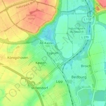
Nome: Mapa topográfico Epprath, altitude, relevo.
Altitude média: 73 m
Altitude mínima: 51 m
Altitude máxima: 108 m
Outros mapas topográficos
Clique em um mapa para visualizar sua topografia, sua altitude e seu relevo.
Pütz
Deutschland > Nordrhein-Westfalen > Rhein-Erft-Kreis > Bedburg
Pütz, Bedburg, Rhein-Erft-Kreis, Nordrhein-Westfalen, 50181, Deutschland
Altitude média: 88 m
Gewässer
Deutschland > Nordrhein-Westfalen > Rhein-Erft-Kreis > Bedburg > Epprath
Gewässer, Kaster, Epprath, Bedburg, Rhein-Erft-Kreis, Nordrhein-Westfalen, 50181, Deutschland
Altitude média: 77 m
Alt-Kaster
Deutschland > Nordrhein-Westfalen > Rhein-Erft-Kreis > Bedburg
Alt-Kaster, Bedburg, Rhein-Erft-Kreis, Nordrhein-Westfalen, 50181, Deutschland
Altitude média: 76 m