
Mapa topográfico Stegelitz
Mapa interativo
Clique no mapa para exibir a altitude.
Sobre este mapa
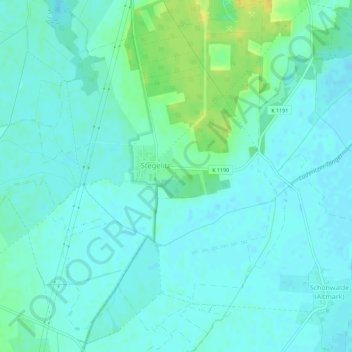
Nome: Mapa topográfico Stegelitz, altitude, relevo.
Local: Stegelitz, Tangerhütte, Stendal, Sachsen-Anhalt, Deutschland (52.45831 11.74839 52.49288 11.78700)
Altitude média: 40 m
Altitude mínima: 34 m
Altitude máxima: 57 m
Outros mapas topográficos
Clique em um mapa para visualizar sua topografia, sua altitude e seu relevo.
Groß Schwarzlosen
Deutschland > Sachsen-Anhalt > Tangerhütte
Groß Schwarzlosen, Tangerhütte, Stendal, Sachsen-Anhalt, Deutschland
Altitude média: 52 m
Weißewarte
Deutschland > Sachsen-Anhalt > Tangerhütte > Weißewarte
Weißewarte, Tangerhütte, Stendal, Sachsen-Anhalt, Deutschland
Altitude média: 37 m
Kehnert
Deutschland > Sachsen-Anhalt > Tangerhütte
Kehnert, Tangerhütte, Stendal, Sachsen-Anhalt, Deutschland
Altitude média: 43 m