
Faça uma doação
Prepare-se para a sua próxima aventura:
Como Associado da Amazon, este site recebe uma comissão sobre compras elegíveis sem custo adicional para si.
Mapa topográfico Tualatin River
Clique no mapa para exibir a altitude.
Faça uma doação
Prepare-se para a sua próxima aventura:
Como Associado da Amazon, este site recebe uma comissão sobre compras elegíveis sem custo adicional para si.
Tualatin River
The drainage area of the river is approximately 712 square miles (1,840 km2) with 27 creeks feeding into the Tualatin. Its watershed is 15 percent urbanized, 35 percent agricultural, and 50 percent forested. The river drops 1,800 feet (550 m) in elevation during its first 12 miles (19 km) and then only an additional 250 feet (76 m) for the remaining 71 miles (114 km) of its course. This creates a slow river for the majority of the course, creating problems with pollution. Pollution reached a point that in 1989 local agencies were forced to begin cleaning up the river after the Tualatin failed water quality standards outlined in the Clean Water Act of 1972. It was the first river in the state to fail overall pollution limits.
Faça uma doação
Prepare-se para a sua próxima aventura:
Como Associado da Amazon, este site recebe uma comissão sobre compras elegíveis sem custo adicional para si.
Sobre este mapa
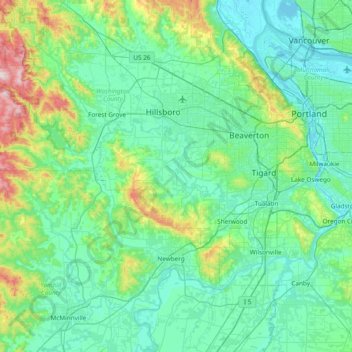
Nome: Mapa topográfico Tualatin River, altitude, relevo.
Local: Tualatin River, Washington County, Oregon, United States (45.33804 -123.40799 45.51229 -122.64732)
Altitude média: 117 m
Altitude mínima: -3 m
Altitude máxima: 740 m
Faça uma doação
Prepare-se para a sua próxima aventura:
Como Associado da Amazon, este site recebe uma comissão sobre compras elegíveis sem custo adicional para si.
Outros mapas topográficos
Clique em um mapa para visualizar sua topografia, sua altitude e seu relevo.
Faça uma doação
Prepare-se para a sua próxima aventura:
Como Associado da Amazon, este site recebe uma comissão sobre compras elegíveis sem custo adicional para si.
Vern Galaway Memorial Park
United States > Oregon > Washington County > North Plains
Altitude média: 56 m