
Mapa topográfico Saint Huberts
Mapa interativo
Clique no mapa para exibir a altitude.
Sobre este mapa
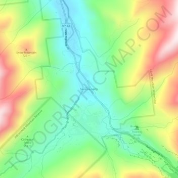
Nome: Mapa topográfico Saint Huberts, altitude, relevo.
Altitude média: 536 m
Altitude mínima: 316 m
Altitude máxima: 877 m
Outros mapas topográficos
Clique em um mapa para visualizar sua topografia, sua altitude e seu relevo.
Keene Valley
United States > New York > Essex County > Town of Keene
Keene Valley, Town of Keene, Essex County, New York, 12943, United States
Altitude média: 459 m
Glenmore
United States > New York > Essex County > Town of Keene
Glenmore, Town of Keene, Essex County, New York, 12942, United States
Altitude média: 648 m
Giant Mountain
United States > New York > Essex County > Town of Keene
Giant Mountain, Town of Keene, Essex County, New York, United States
Altitude média: 1060 m
Gothics
United States > New York > Essex County > Town of Keene
Gothics, Town of Keene, Essex County, New York, United States
Altitude média: 1095 m
Mount Marcy
United States > New York > Essex County > Town of Keene
Mount Marcy, Town of Keene, Essex County, New York, United States
Altitude média: 1289 m