
Mapa topográfico Schunnemunk State Park
Mapa interativo
Clique no mapa para exibir a altitude.
Sobre este mapa
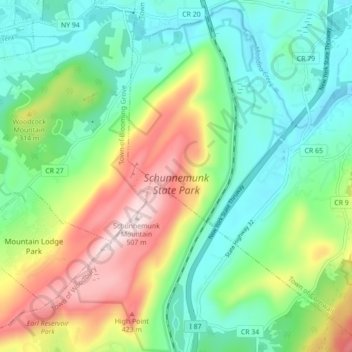
Nome: Mapa topográfico Schunnemunk State Park, altitude, relevo.
Altitude média: 213 m
Altitude mínima: 66 m
Altitude máxima: 506 m
Outros mapas topográficos
Clique em um mapa para visualizar sua topografia, sua altitude e seu relevo.
Highland Mills
United States > New York > Orange County > Village of Woodbury
Highland Mills, Village of Woodbury, Town of Woodbury, Orange County, New York, 10930, United States
Altitude média: 208 m
Central Valley
United States > New York > Orange County > Village of Woodbury
Central Valley, Village of Woodbury, Town of Woodbury, Orange County, New York, 10917, United States
Altitude média: 205 m