
Mapa topográfico Landershofen
Mapa interativo
Clique no mapa para exibir a altitude.
Sobre este mapa
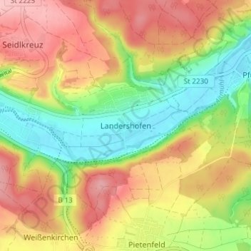
Nome: Mapa topográfico Landershofen, altitude, relevo.
Altitude média: 456 m
Altitude mínima: 381 m
Altitude máxima: 529 m
Outros mapas topográficos
Clique em um mapa para visualizar sua topografia, sua altitude e seu relevo.
Hofmühle
Deutschland > Bayern > Landkreis Eichstätt > Eichstätt > Rebdorf
Hofmühle, Rebdorf, Eichstätt, Landkreis Eichstätt, Bayern, 85072, Deutschland
Altitude média: 475 m
Rebdorf
Deutschland > Bayern > Landkreis Eichstätt > Eichstätt
Rebdorf, Eichstätt, Landkreis Eichstätt, Bayern, 85072, Deutschland
Altitude média: 472 m