
Mapa topográfico Uttarkashi
Mapa interativo
Clique no mapa para exibir a altitude.
Sobre este mapa
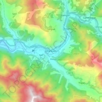
Nome: Mapa topográfico Uttarkashi, altitude, relevo.
Altitude média: 1619 m
Altitude mínima: 1052 m
Altitude máxima: 2642 m
It is the district headquarters of Uttarkashi district. Uttarkashi is situated on the banks of river Bhagirathi at an altitude of 1158 m above sea level. Uttarkashi is generally known as a holy town close to Rishikesh. It is located in the state of Uttarakhand in India. Uttarkashi is home to a number of ashrams and temples and also to the Nehru Institute of Mountaineering. The name of the town reflects its similarity to and location (as north of) the city of Kashi (Varanasi). Similar to Varanasi, town of Uttarkashi is situated on the Ganges, lies next to a hill named Varunavat, on confluence of two rivers Varuna and Asi, has a ghat called Manikarnika Ghat and has a temple dedicated to Shiva similar to (Kashi Vishwanath Temple) in Varanasi, in the center of the town.
Outros mapas topográficos
Clique em um mapa para visualizar sua topografia, sua altitude e seu relevo.
Gangotri Glacier
India > Uttarakhand > Bhatwari
Gangotri Glacier, Bhatwari, Uttarkashi, Uttarakhand, India
Altitude média: 5259 m
Harsil
India > Uttarakhand > Bhatwari
Harsil, Bhatwari, Uttarkashi district, Uttarakhand, India
Altitude média: 2761 m
Dharali
India > Uttarakhand > Bhatwari > Dharali
Dharali, Bhatwari, Uttarkashi district, Uttarakhand, India
Altitude média: 2963 m
Shilla
India > Uttarakhand > Bhatwari
Shilla, Bhatwari, Uttarkashi district, Uttarakhand, India
Altitude média: 2178 m