
Mapa topográfico Seabrook
Mapa interativo
Clique no mapa para exibir a altitude.
Sobre este mapa
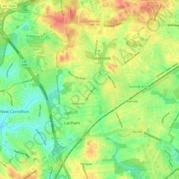
Nome: Mapa topográfico Seabrook, altitude, relevo.
Altitude média: 49 m
Altitude mínima: 22 m
Altitude máxima: 75 m
Seabrook takes its name from Thomas Seabrook, who was a topographical engineer with the Pennsylvania Railroad. He originally built three cottages and a park with fenced-in tame deer in the area near the rail station[5] in the early 1870s.
Outros mapas topográficos
Clique em um mapa para visualizar sua topografia, sua altitude e seu relevo.
Lanham
United States > Maryland > Prince George's County > Glenn Dale
Lanham, Glenn Dale, Prince George's County, Maryland, 20706, United States
Altitude média: 47 m