
Faça uma doação
Prepare-se para a sua próxima aventura:
Como Associado da Amazon, este site recebe uma comissão sobre compras elegíveis sem custo adicional para si.
Mapa topográfico Jabal Qasiyun
Clique no mapa para exibir a altitude.
Faça uma doação
Prepare-se para a sua próxima aventura:
Como Associado da Amazon, este site recebe uma comissão sobre compras elegíveis sem custo adicional para si.
Jabal Qasiyun
The mountain is also host to an endemic species of iris, Iris damascena, which can be found on the steep eastern slopes, at high elevation. The Syrian government has not given the species any protected status but part of the habitat of the species lies within a military area near the Qassioun Republican Guards Military Base and other military facilities, which prevents civilians from accessing the area. The base and steepness of the habitat also prevent construction or development, but it is still classified as "critically endangered".
Faça uma doação
Prepare-se para a sua próxima aventura:
Como Associado da Amazon, este site recebe uma comissão sobre compras elegíveis sem custo adicional para si.
Sobre este mapa
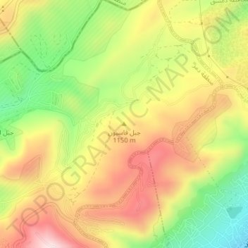
Nome: Mapa topográfico Jabal Qasiyun, altitude, relevo.
Altitude média: 946 m
Altitude mínima: 735 m
Altitude máxima: 1142 m
Faça uma doação
Prepare-se para a sua próxima aventura:
Como Associado da Amazon, este site recebe uma comissão sobre compras elegíveis sem custo adicional para si.