
Faça uma doação
Prepare-se para a sua próxima aventura:
Como Associado da Amazon, este site recebe uma comissão sobre compras elegíveis sem custo adicional para si.
Mapa topográfico St. Joseph
Clique no mapa para exibir a altitude.
Faça uma doação
Prepare-se para a sua próxima aventura:
Como Associado da Amazon, este site recebe uma comissão sobre compras elegíveis sem custo adicional para si.
St. Joseph
Under the Köppen climate classification, St. Joseph has a humid subtropical climate (Cfa) bordering on a humid continental climate (Dfa), although under United States isotherms of 32 °F (0 °C) the station is firmly continental. The monthly weather averages listed below are taken from National Weather Service 1981-2010 Normals recorded at Rosecrans Airport. Because of the Airport's location near the Missouri River and at a low elevation, official overnight lows during wintertime especially are often several degrees colder than at other places within the city.[15] Snowfall is not recorded at the St Joseph weather station although surrounding reporting stations typically receive 12-20 inches of snowfall annually.[16][17][18]
Faça uma doação
Prepare-se para a sua próxima aventura:
Como Associado da Amazon, este site recebe uma comissão sobre compras elegíveis sem custo adicional para si.
Sobre este mapa
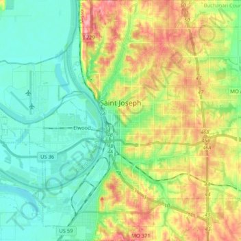
Nome: Mapa topográfico St. Joseph, altitude, relevo.
Local: St. Joseph, Buchanan County, Missouri, United States (39.69722 -94.89903 39.82119 -94.74334)
Altitude média: 277 m
Altitude mínima: 241 m
Altitude máxima: 343 m
Faça uma doação
Prepare-se para a sua próxima aventura:
Como Associado da Amazon, este site recebe uma comissão sobre compras elegíveis sem custo adicional para si.