
Mapa topográfico Volcano
Mapa interativo
Clique no mapa para exibir a altitude.
Sobre este mapa
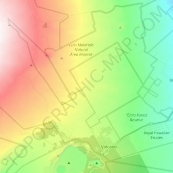
Nome: Mapa topográfico Volcano, altitude, relevo.
Local: Volcano, Hawaiʻi County, Hawaii, United States (19.41769 -155.34518 19.56076 -155.16399)
Altitude média: 1219 m
Altitude mínima: 715 m
Altitude máxima: 1959 m
Its altitude ranges from below 2,800 feet (850 m) in the southeast to over 6,200 feet (1,900 m) at its uninhabited northern end. Due to this, Volcano features a subtropical highland climate (Köppen Cfb), with relatively uniform temperatures and abundant rainfall throughout the year, although rainfall is concentrated during the months of November through April.