
Mapa topográfico Ely
Mapa interativo
Clique no mapa para exibir a altitude.
Sobre este mapa
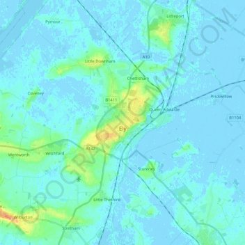
Nome: Mapa topográfico Ely, altitude, relevo.
Altitude média: 4 m
Altitude mínima: -5 m
Altitude máxima: 36 m
Ely is built on a 23-square-mile (60 km2) Kimmeridge Clay island which, at 85 feet (26 m), is the highest land in the Fens. It was due to this topography that Ely was not waterlogged like the surrounding Fenland, and was an island separated from the mainland. Major rivers including the Witham, Welland, Nene and Great Ouse feed into the Fens and, until draining commenced in the eighteenth century, formed freshwater marshes and meres within which peat was laid down. Once the Fens were drained, this peat created a rich and fertile soil ideal for farming.
Outros mapas topográficos
Clique em um mapa para visualizar sua topografia, sua altitude e seu relevo.
Kirtling
United Kingdom > England > Cambridgeshire > East Cambridgeshire
Kirtling, East Cambridgeshire, Cambridgeshire, Cambridgeshire and Peterborough, England, United Kingdom
Altitude média: 100 m