
Mapa topográfico Canary Islands
Mapa interativo
Clique no mapa para exibir a altitude.
Sobre este mapa
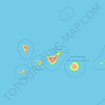
Nome: Mapa topográfico Canary Islands, altitude, relevo.
Altitude média: 16 m
Altitude mínima: 0 m
Altitude máxima: 3500 m
The archipelago's beaches, climate and important natural attractions, especially Maspalomas in Gran Canaria and Teide National Park and Mount Teide (a World Heritage Site) in Tenerife (the third tallest volcano in the world measured from its base on the ocean floor), make it a major tourist destination with over 12 million visitors per year, especially Tenerife, Gran Canaria, Fuerteventura and Lanzarote. The islands have a subtropical climate, with long hot summers and moderately warm winters. The precipitation levels and the level of maritime moderation vary depending on location and elevation. Green areas as well as desert exist on the archipelago. Due to their location above the temperature inversion layer, the high mountains of these islands are ideal for astronomical observation. For this reason, two professional observatories, Teide Observatory on the island of Tenerife and Roque de los Muchachos Observatory on the island of La Palma, have been built on the islands.
Outros mapas topográficos
Clique em um mapa para visualizar sua topografia, sua altitude e seu relevo.
Lanzarote
Spain > Canary Islands > Teguise
Lanzarote, Teguise, Las Palmas, Canary Islands, Spain
Altitude média: 35 m