
Faça uma doação
Prepare-se para a sua próxima aventura:
Como Associado da Amazon, este site recebe uma comissão sobre compras elegíveis sem custo adicional para si.
Mapa topográfico Barnes Lake
Clique no mapa para exibir a altitude.
Faça uma doação
Prepare-se para a sua próxima aventura:
Como Associado da Amazon, este site recebe uma comissão sobre compras elegíveis sem custo adicional para si.
Sobre este mapa
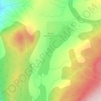
Nome: Mapa topográfico Barnes Lake, altitude, relevo.
Altitude média: 752 m
Altitude mínima: 517 m
Altitude máxima: 1015 m
Faça uma doação
Prepare-se para a sua próxima aventura:
Como Associado da Amazon, este site recebe uma comissão sobre compras elegíveis sem custo adicional para si.
Outros mapas topográficos
Clique em um mapa para visualizar sua topografia, sua altitude e seu relevo.
Spences Bridge
Canada > British Columbia > Thompson-Nicola Regional District > Area I (Blue Sky Country)
Spences Bridge's location is mountainous, with higher elevations part of the Interior Plateau. The east side of the Fraser here is part of the Clear Range, a mountainous southwards extension of the Fraser Plateau located in the angle of the Thompson and Fraser Rivers. Arthur Seat lies in that range on the west…
Altitude média: 496 m
Shaw Springs
Canada > British Columbia > Thompson-Nicola Regional District > Area I (Blue Sky Country)
Altitude média: 472 m
Arthur Seat
Canada > British Columbia > Thompson-Nicola Regional District > Area I (Blue Sky Country)
Altitude média: 1327 m
Spences Bridge
Canada > British Columbia > Thompson-Nicola Regional District > Area I (Blue Sky Country)
Spences Bridge's location is mountainous, with higher elevations part of the Interior Plateau. The east side of the Fraser here is part of the Clear Range, a mountainous southwards extension of the Fraser Plateau located in the angle of the Thompson and Fraser Rivers. Arthur Seat lies in that range on the west…
Altitude média: 496 m
Faça uma doação
Prepare-se para a sua próxima aventura:
Como Associado da Amazon, este site recebe uma comissão sobre compras elegíveis sem custo adicional para si.
Arthur Seat
Canada > British Columbia > Thompson-Nicola Regional District > Area I (Blue Sky Country)
Altitude média: 1327 m