
Mapa topográfico Emsbüren
Mapa interativo
Clique no mapa para exibir a altitude.
Sobre este mapa
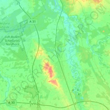
Nome: Mapa topográfico Emsbüren, altitude, relevo.
Local: Emsbüren, Landkreis Emsland, Lower Saxony, 48488, Germany (52.33388 7.21252 52.48261 7.42664)
Altitude média: 32 m
Altitude mínima: 19 m
Altitude máxima: 71 m
Outros mapas topográficos
Clique em um mapa para visualizar sua topografia, sua altitude e seu relevo.
Lingen (Ems)
Germany > Lower Saxony > Landkreis Emsland
Lingen (Ems), Landkreis Emsland, Lower Saxony, Germany
Altitude média: 29 m
Wörmer
Germany > Lower Saxony > Landkreis Emsland > Haren (Ems) > Wesuwe
Wörmer, Wesuwe, Haren (Ems), Landkreis Emsland, Lower Saxony, 49733, Germany
Altitude média: 12 m
Dever
Germany > Lower Saxony > Landkreis Emsland > Lehe
Dever, Lehe, Samtgemeinde Dörpen, Landkreis Emsland, Lower Saxony, 26892, Germany
Altitude média: 6 m