
Mapa topográfico West Frankfort
Mapa interativo
Clique no mapa para exibir a altitude.
Sobre este mapa
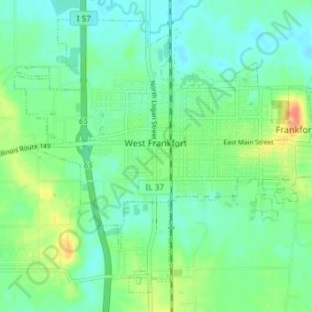
Nome: Mapa topográfico West Frankfort, altitude, relevo.
Altitude média: 122 m
Altitude mínima: 108 m
Altitude máxima: 155 m
The area of West Frankfort formerly known as Frankfort is still sometimes referred to locally as Frankfort Heights or, more commonly, simply as "The Heights", due to its higher elevation relative to the rest of the city. A post office was maintained in Frankfort Heights until its destruction by fire in 2004, making West Frankfort one of the smallest cities in the United States to have two ZIP codes (the other zip code is designated as "Frankfort Heights, Illinois").
Outros mapas topográficos
Clique em um mapa para visualizar sua topografia, sua altitude e seu relevo.
Benton Park
United States > Illinois > Franklin County > Benton
Benton Park, Benton, Franklin County, Illinois, 62897, United States
Altitude média: 138 m
Benton
United States > Illinois > Franklin County
Benton, Franklin County, Illinois, 62812, United States
Altitude média: 132 m
Christopher
United States > Illinois > Franklin County
Christopher, Franklin County, Illinois, 62822, United States
Altitude média: 130 m
Thompsonville
United States > Illinois > Franklin County
Thompsonville, Franklin County, Illinois, United States
Altitude média: 147 m
Royalton
United States > Illinois > Franklin County > Royalton
Royalton, Franklin County, Illinois, United States
Altitude média: 122 m
Rend Lake
United States > Illinois > Franklin County
Rend Lake, Franklin County, Illinois, United States
Altitude média: 132 m