
Mapa topográfico Macherla
Mapa interativo
Clique no mapa para exibir a altitude.
Sobre este mapa
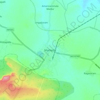
Nome: Mapa topográfico Macherla, altitude, relevo.
Local: Macherla, Guntur, Andhra Pradesh, 522426, India (16.43611 79.39641 16.51611 79.47641)
Altitude média: 156 m
Altitude mínima: 125 m
Altitude máxima: 246 m
Macherla is located at 16°29′N 79°26′E / 16.48°N 79.43°E / 16.48; 79.43. It has an average elevation of 136 metres (446 feet). It is located 23 kilometers from Nagarjuna Sagar. Jerri Vagu is the source of water for the town and the surrounding villages.