Mapa topográfico Rhode Island Corner
Mapa interativo
Clique no mapa para exibir a altitude.
Sobre este mapa
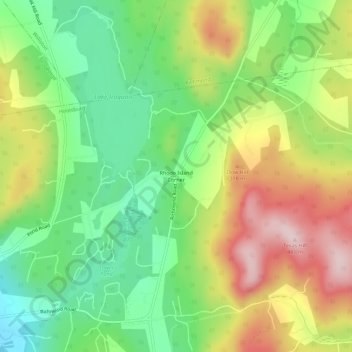
Nome: Mapa topográfico Rhode Island Corner, altitude, relevo.
Altitude média: 279 m
Altitude mínima: 143 m
Altitude máxima: 463 m

Clique no mapa para exibir a altitude.
Nome: Mapa topográfico Rhode Island Corner, altitude, relevo.
Altitude média: 279 m
Altitude mínima: 143 m
Altitude máxima: 463 m