
Mapa topográfico Elkhorn City
Mapa interativo
Clique no mapa para exibir a altitude.
Sobre este mapa
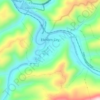
Nome: Mapa topográfico Elkhorn City, altitude, relevo.
Local: Elkhorn City, Pike County, Kentucky, United States (37.28905 -82.36376 37.31256 -82.32504)
Altitude média: 364 m
Altitude mínima: 223 m
Altitude máxima: 657 m
Outros mapas topográficos
Clique em um mapa para visualizar sua topografia, sua altitude e seu relevo.
Jonancy
United States > Kentucky > Pike County
Jonancy, Pike County, Kentucky, 41538, United States
Altitude média: 399 m
McAndrews
United States > Kentucky > Pike County
McAndrews, Pike County, Kentucky, 41567, United States
Altitude média: 374 m
Pikeville
United States > Kentucky > Pike County
Pikeville, Pike County, Kentucky, 41501, United States
Altitude média: 338 m
Pleasant Valley
United States > Kentucky > Pike County > Pikeville
Pleasant Valley, Pikeville, Pike County, Kentucky, 41501, United States
Altitude média: 315 m
Mouthcard
United States > Kentucky > Pike County
Mouthcard, Pike County, Kentucky, 41548, United States
Altitude média: 393 m
Penny
United States > Kentucky > Pike County
Penny, Pike County, Kentucky, 41560, United States
Altitude média: 378 m
Toler
United States > Kentucky > Pike County
Toler, Pike County, Kentucky, 25661, United States
Altitude média: 320 m
Phyllis
United States > Kentucky > Pike County
Phyllis, Pike County, Kentucky, 41554, United States
Altitude média: 406 m
Pikeville
United States > Kentucky > Pike County > Pikeville > Pikeville
Pikeville, Pike County, Kentucky, 41501, United States
Altitude média: 312 m
Turkey Creek
United States > Kentucky > Pike County > Turkey Creek
Turkey Creek, Pike County, Kentucky, 41514, United States
Altitude média: 312 m
Lick Creek
United States > Kentucky > Pike County
Lick Creek, Pike County, Kentucky, 41540, United States
Altitude média: 430 m