
Mapa topográfico Gençlik Parkı
Mapa interativo
Clique no mapa para exibir a altitude.
Sobre este mapa
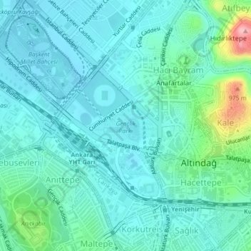
Nome: Mapa topográfico Gençlik Parkı, altitude, relevo.
Altitude média: 870 m
Altitude mínima: 842 m
Altitude máxima: 1000 m
The 27.5 ha (68 acres) park is almost at the center of Ankara. Its altitude is about 850 m (2,790 ft), which makes it one of the lowest points in Ankara. It is surrounded by Ulus Square to the north, the Ankara Opera House (formerly Ankara Exhibition Building) to the east, Selim Sırrı Tarcan Sport Hall and Ankara Central Station to the south and, 19 Mayıs Stadium to the west.
Outros mapas topográficos
Clique em um mapa para visualizar sua topografia, sua altitude e seu relevo.