
Faça uma doação
Prepare-se para a sua próxima aventura:
Como Associado da Amazon, este site recebe uma comissão sobre compras elegíveis sem custo adicional para si.
Mapa topográfico Abraham Lake
Clique no mapa para exibir a altitude.
Faça uma doação
Prepare-se para a sua próxima aventura:
Como Associado da Amazon, este site recebe uma comissão sobre compras elegíveis sem custo adicional para si.
Abraham Lake
The Government of Alberta sponsored a contest to name the lake in February 1972, during the final stages of construction of the Bighorn Dam. Students across the province were asked to submit names taking into consideration "historical significance, prominent persons, geography and topography, and the value of the lake." It was eventually named after Silas Abraham (c. 1870–1964), of the Stoney Nakoda First Nation and originally from Morley, Alberta. He was a farmer and hunter who lived in the Kootenay Plains and later on the Big Horn 144A reserve.
Faça uma doação
Prepare-se para a sua próxima aventura:
Como Associado da Amazon, este site recebe uma comissão sobre compras elegíveis sem custo adicional para si.
Sobre este mapa
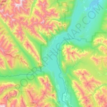
Nome: Mapa topográfico Abraham Lake, altitude, relevo.
Local: Abraham Lake, Census Division No. 9, Alberta, Canada (52.07360 -116.48898 52.33277 -116.32587)
Altitude média: 1886 m
Altitude mínima: 1222 m
Altitude máxima: 3095 m
Faça uma doação
Prepare-se para a sua próxima aventura:
Como Associado da Amazon, este site recebe uma comissão sobre compras elegíveis sem custo adicional para si.
Outros mapas topográficos
Clique em um mapa para visualizar sua topografia, sua altitude e seu relevo.
Moutain Vew Park
Canada > Alberta > Census Division No. 9 > Rocky Mountain House
Altitude média: 978 m