
Mapa topográfico Denizli
Mapa interativo
Clique no mapa para exibir a altitude.
Denizli
Denizli is an industrial city in the southwestern part of Turkey and the eastern end of the alluvial valley formed by the river Büyük Menderes, where the plain reaches an elevation of about three hundred and fifty metres (1,148 ft). Denizli is located in the country's Aegean Region.
Sobre este mapa
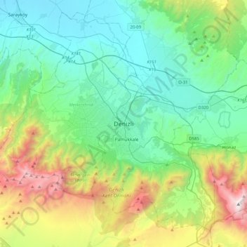
Nome: Mapa topográfico Denizli, altitude, relevo.
Local: Denizli, Merkezefendi, Denizli, Aegean Region, 20100, Turkey (37.62332 28.92448 37.94332 29.24448)
Altitude média: 740 m
Altitude mínima: 138 m
Altitude máxima: 2518 m
Outros mapas topográficos
Clique em um mapa para visualizar sua topografia, sua altitude e seu relevo.