
Mapa topográfico Eglon
Mapa interativo
Clique no mapa para exibir a altitude.
Sobre este mapa
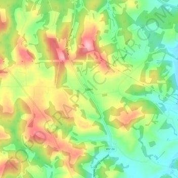
Nome: Mapa topográfico Eglon, altitude, relevo.
Local: Eglon, Preston County, West Virginia, 26716, United States (39.28149 -79.53922 39.32149 -79.49922)
Altitude média: 816 m
Altitude mínima: 739 m
Altitude máxima: 909 m
Outros mapas topográficos
Clique em um mapa para visualizar sua topografia, sua altitude e seu relevo.
Horse Shoe Run
United States > West Virginia > Preston County
Horse Shoe Run, Preston County, West Virginia, 26716, United States
Altitude média: 787 m
Rowlesburg
United States > West Virginia > Preston County
Rowlesburg, Preston County, West Virginia, United States
Altitude média: 564 m
Caddell
United States > West Virginia > Preston County
Caddell, Preston County, West Virginia, 26537, United States
Altitude média: 487 m
Kingwood
United States > West Virginia > Preston County
Kingwood, Preston County, West Virginia, 26537, United States
Altitude média: 530 m
Terra Alta
United States > West Virginia > Preston County
Terra Alta, Preston County, West Virginia, United States
Altitude média: 775 m
Mount Nebo
United States > West Virginia > Preston County
Mount Nebo, Preston County, West Virginia, United States
Altitude média: 552 m
Aurora
United States > West Virginia > Preston County
Aurora, Preston County, West Virginia, 26705, United States
Altitude média: 812 m
Preston
United States > West Virginia > Preston County
Preston, Preston County, West Virginia, 26537, United States
Altitude média: 502 m
Alpine Lake
United States > West Virginia > Preston County > Alpine Lake
Alpine Lake, Preston County, West Virginia, 26764, United States
Altitude média: 830 m
Newburg
United States > West Virginia > Preston County
Newburg, Preston County, West Virginia, 26410, United States
Altitude média: 451 m
Bruceton Mills
United States > West Virginia > Preston County
Bruceton Mills, Preston County, West Virginia, United States
Altitude média: 508 m