
Mapa topográfico Thompson Falls
Mapa interativo
Clique no mapa para exibir a altitude.
Sobre este mapa
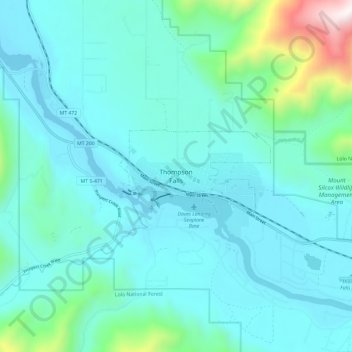
Nome: Mapa topográfico Thompson Falls, altitude, relevo.
Altitude média: 897 m
Altitude mínima: 709 m
Altitude máxima: 2032 m
Thompson Falls is located at 47°35′48″N 115°20′37″W / 47.59667°N 115.34361°W / 47.59667; -115.34361 (47.596587, -115.343730) in the Clark Fork Valley at an elevation of 2,419 feet (737 m).